Expansion service API reference (BETA)
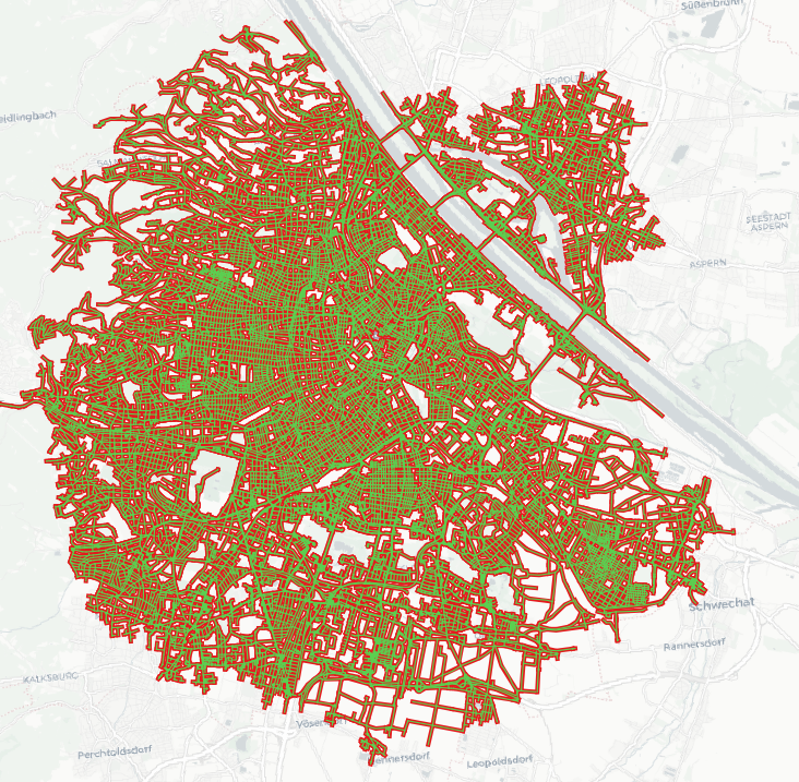
Routing algorithms find the best path by expanding their search from start nodes/edges across the routing network until the destination is reached (unidirectional) or both search branches meet (bidirectional). This service could be subject to change in terms of API until we remove the BETA label.
The expansion service wraps the route, isochrone and sources_to_targets services and returns a GeoJSON with all network edges (way segments) the underlying routing algorithm visited during the expansion, with relevant properties for each edge (e.g. duration & distance). A top-level algorithm propertry informs about the used algorithm: unidirectional & bidirectional A* (for route), unidirectional Dijkstra (for isochrone) or bidirectional Dijkstra (for sources_to_targets).
Note, for even moderately long routes (or isochrones or few sources/targets) the /expansion action can produce gigantic GeoJSON responses of 100s of MB.

Inputs of the Expansion service
Since this service wraps other services, the request format mostly follows the ones of the route, isochrone and matrix. Additionally, it accepts the following parameters:
| Parameter | Description |
|---|---|
action (required) |
The service whose expansion should be tracked. Currently one of route, isochrone or sources_to_targets. |
skip_opposites (optional) |
If set to true the output won't contain an edge's opposing edge. Opposing edges can be thought of as both directions of one road segment. Of the two, we discard the directional edge with higher cost and keep the one with less cost. Default false. |
expansion_properties (optional) |
A JSON array of strings of the GeoJSON property keys you'd like to have in the response. One or multiple of "duration", "distance", "cost", "edge_id", "pred_edge_id" or "edge_status". Note, that each additional property will increase the output size by minimum ~ 10%. By default an empty properties object is returned. |
The expansion_properties choices are as follows:
| Property | Description |
|---|---|
distance |
Returns the accumulated distance in meters for each edge in order of graph traversal. |
duration |
Returns the accumulated duration in seconds for each edge in order of graph traversal. |
cost |
Returns the accumulated cost for each edge in order of graph traversal. |
edge_id |
Returns the internal edge IDs for each edge in order of graph traversal. Mostly interesting for debugging. |
pred_edge_id |
Returns the internal edge IDs of the predecessor for each edge in order of graph traversal. Mostly interesting for debugging. |
edge_status |
Returns the edge states for each edge in order of graph traversal. Mostly interesting for debugging. Can be one of "r" (reached), "s" (settled), "c" (connected). |
An example request is:
{
    "costing": "pedestrian",
    "action": "isochrone",
    "id": 1,
    "locations": [
        {
            "lon": 14.440689,
            "lat": 50.087052
        }
    ],
    "contours": [
        {
            "time": 1
        }
    ],
    "skip_opposites": true,
    "expansion_properties": [
        "duration",
        "edge_id",
        "pred_edge_id",
        "edge_status",
        "cost"
    ]
}
Outputs of the Expansion service
In the service response, the expanded way segments are returned as GeoJSON as plain LineStrings. Due to the verbosity of the GeoJSON format, single geometry features would produce prohibitively huge responses.
The output will only contain the properties which were specified in the expansion_properties request array. If the parameter was omitted in the request, the output will contain an empty properties object.
An example response for "action": "isochrone" is:
{
    "type": "FeatureCollection",
    "features": [
        {
            "type": "Feature",
            "geometry": {
                "type": "LineString",
                "coordinates": [
                    [
                        14.441804,
                        50.087371
                    ],
                    [
                        14.440275,
                        50.087137
                    ]
                ]
            },
            "properties": {
                "duration": 19,
                "cost": 19,
                "edge_status": "s",
                "edge_id": 4049718357265,
                "pred_edge_id": 70368744177663
            }
        },
        {
            "type": "Feature",
            "geometry": {
                "type": "LineString",
                "coordinates": [
                    [
                        14.440275,
                        50.087137
                    ],
                    [
                        14.439981,
                        50.087084
                    ]
                ]
            },
            "properties": {
                "duration": 34,
                "cost": 34,
                "edge_status": "s",
                "edge_id": 4049617693969,
                "pred_edge_id": 4049718357265
            }
        },
        {
            "type": "Feature",
            "geometry": {
                "type": "LineString",
                "coordinates": [
                    [
                        14.439981,
                        50.087084
                    ],
                    [
                        14.438998,
                        50.086788
                    ]
                ]
            },
            "properties": {
                "duration": 89,
                "cost": 89,
                "edge_status": "s",
                "edge_id": 4444184259857,
                "pred_edge_id": 4049617693969
            }
        }
    ],
    "properties": {
        "algorithm": "dijkstras"
    }
}
Credits
The image includes data from OpenStreetMap and the "Positron" basemap by Carto.